Land Use Planning & Sustainability
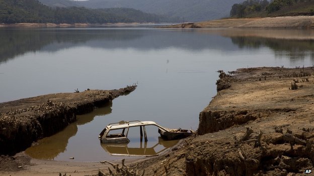
Recent and surprising news (at least from our perspective) from Brazil: a drought stretchs across their most populous province, Sao Paulo. Brazilian Environment Minister Izabella Teixeira has said the country’s three most populous states are experiencing their worst drought since 1930.
Expert consensus is building around deforestation as a major driver of this year’s drought and other serious dry periods in Brazil. In 2009, Antonio Nobre, a scientist at Brazil’s Center for Earth Systems Science – CCST/INPE, warned that Amazonian deforestation could interfere with the forest’s function as a giant water pump; it lifts vast amounts of moisture up into the air, which then circulate west and south, falling as rain to irrigate Brazil’s central and southern regions. Without these “flying rivers,” Nobre said, the area accounting for 70 percent of South America’s GNP could effectively become deserts via.

It is sobering to consider how the rapacious tearing down of the Brazilian Amazon in order to clear fields for livestock, and predominately ethanol for bio-fuels has already begun severely impacting the livelihoods of millions of Brazilians. This adds a very hard to understand factor into land use planning: how land effects meterology.This speaks to the need for Land Use planning which is broad and circumspect (as far as our new knowledge allows) and takes into account not only the terrestrial changes but also the meterological which sudden and large shifts in land-use cause.
The dramatic impact of land-use change on our meterology is not new, and it is a shame that the lessons of past, what we might call “antrho-desertification”, either were not sufficiently studied, or the implications not well enough communuicated. A good example of this anthro-desertification happened in the famous Dust Bowl of the North American Mid-west. Here we saw a period of “severe dust storms that severly damaged the ecology and agriculture of the US and Canadian prairies during the 1930s; severe drought and a failure to apply dryland farming methods to prevent wind erosion caused the phenomenon:
With insufficient understanding of the ecology of the Plains, farmers had conducted extensive deep plowing of the virgin topsoil of the Great Plains during the previous decade; this had displaced the native, deep-rooted grasses that normally trapped soil and moisture even during periods of drought and high winds.” via
As architects and planners we build buildings. In aggregate we build cities and contribute at a “meta” scale to large changes of land-use. It is important for us to understand the impact of these changes, and ensure that we are desinging in such a way as to mitigate, and if possible, work in harmony with the land we are changing to sure that there are not downstream effects from our decisions… such as massive droughts effecting millions of people. While building more dense communities may limit the amount of land that is uprooted to make way for our ever-expanding cities, larger research and guidelines are required which take into effect the ACTUAL impact of land-use change.
-gc